Flat Tactics
Moderator: Forum Moderators
Forum rules
Before posting critique in this forum, you must read the following thread:
Before posting critique in this forum, you must read the following thread:

Flat Tactics
Flat Tactics
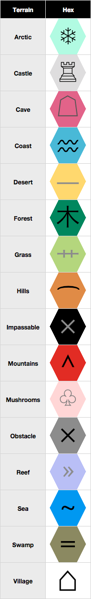
Terrain replacement making it easier to strategically play a map.
I’ve recognized a need to have a new view when playing that would let the player see the terrain better. So I’ve come up with replacement tiles for the default terrain and hope to code it in. Additionally, these tiles should be colorblind-friendly.
(I’m also interested in replacing units with some kind of icons or tokens… but, one step at a time.)
Attached is a preliminary index of the terrain tiles. Hybrid tiles have yet to be made yet. When I get better icons for things I’ll replace them; the colors will likely stay the same, however. Comments are welcome; at this point, I need to code this into the game and see how it looks… which may take a while.
Wesnoth Bestiary ( PREVIEW IT HERE )
Unit tree and stat browser
Canvas ( PREVIEW IT HERE )
Exp. map viewer
Unit tree and stat browser
Canvas ( PREVIEW IT HERE )
Exp. map viewer
-
SlowThinker
- Posts: 876
- Joined: November 28th, 2008, 6:18 pm
Re: Flat Tactics
Imagine a unit with a horizontal line in the middle (a belt for example) that stands on a desert hex.
Therefore many equal little symbols might be more appropriate than just one symbol. Or you could use just one symbol, but place it in the bottom, and any unit above.
You should add symbols for gold production / healing / ownership
Concerning units: you might want to try to add numbers with unit's HP and movement left to the image
I work on Conquest Minus • I use DFoolWide, Retro Terrain Package and the add-on 'High Contrast Water'
I moved to Nosebane's corner (Doc Paterson's signature); I am spending my time there, so PM me if I don't answer your post in forums
I moved to Nosebane's corner (Doc Paterson's signature); I am spending my time there, so PM me if I don't answer your post in forums
-
battlestar

- Posts: 690
- Joined: January 1st, 2007, 7:12 am
Re: Flat Tactics
irrevenant.
http://forums.wesnoth.org/viewtopic.php?f=12&t=21094

^ This style looks great to me, doesn't seem like it was done.
http://forums.wesnoth.org/viewtopic.php?f=12&t=21094
^ This style looks great to me, doesn't seem like it was done.
LUA: Llama Under Apprenticeship
Hell faction: completed
Hell faction: completed

Re: Flat Tactics
This looks like an excellent idea to me, it looks easy to accomplish and actually handy for easy definition.
Guys I never thought I'd come back to this forum after 8 years this is wild
Re: Flat Tactics
How did I miss this thread?battlestar wrote:irrevenant.
http://forums.wesnoth.org/viewtopic.php?f=12&t=21094
^ This style looks great to me, doesn't seem like it was done.
We’re on to something here. Surely!
Once I’m done moving to my new apartment and am free I’ll dedicate some time to work on this thing. The pewter-like units look intriguing.
Wesnoth Bestiary ( PREVIEW IT HERE )
Unit tree and stat browser
Canvas ( PREVIEW IT HERE )
Exp. map viewer
Unit tree and stat browser
Canvas ( PREVIEW IT HERE )
Exp. map viewer

Re: Flat Tactics
My comment (about both designs brought forward) is that some terrains should be overlays. For exemple, with your system, how would you convey a forest hex on hills? A village on hills? Mushrooms on caves/sand/whatever? Snowy forests/hills/mountains? Desert hills/mountains? Cave "hills" (You know, the stalactite terrain)? "Grass" (flat, as in a bridge) over swamp/water/chasms? Or as fords? And probably tons of other exemples that come to mind.
Also, as that last exemple reveals, I think "grass" is a poor choice and should rather be "flat". Having "Grass" to convey all kind of flats would be weird in some instances: paved roads in castles, cave roads, desert roads, bridges, fords...
So while I really really like your symbols, I'm not sure they are optimally practical. I myself would have gone with monochrome hexes, and in case of overlays, the overlaying terrain's color could just be slashes over the base terrain. For exemple, if snow was cyan and forest was dark green, this could look like this:
Of course, this is a bit crude, and various tests would have to be ran to find the perfect balance between nice-looking and varied tones and ones that are perfectly distinguishable for colorblinds.
Also, as that last exemple reveals, I think "grass" is a poor choice and should rather be "flat". Having "Grass" to convey all kind of flats would be weird in some instances: paved roads in castles, cave roads, desert roads, bridges, fords...
So while I really really like your symbols, I'm not sure they are optimally practical. I myself would have gone with monochrome hexes, and in case of overlays, the overlaying terrain's color could just be slashes over the base terrain. For exemple, if snow was cyan and forest was dark green, this could look like this:
- snow forest.png (1.74 KiB) Viewed 3293 times
Jazz is not dead, it just smells funny - Frank Zappa
Current projects: Internet meme Era, The Settlers of Wesnoth
Current projects: Internet meme Era, The Settlers of Wesnoth
-
battlestar
- Posts: 690
- Joined: January 1st, 2007, 7:12 am
Re: Flat Tactics
Suggestions: When amounts of colors go above half a dozen, it could cause some headaches (you'd have to think, is that dark pink or is that red, was mountain pink or was mountain red, was that swamp or was that grey, etc.). Plus bright colors doesn't really agree with the eyes for long. The cartography-based map style would be my preference, something clear at a glance.
LUA: Llama Under Apprenticeship
Hell faction: completed
Hell faction: completed

Re: Flat Tactics
Almost four years ago, and still the unit images and animations are hard-coded within the unit configs (and even compared for purpose of out-of-sync errors in multiplayer, I think) (Thanks Shadowmaster for the correction, looks I was wrong here.)battlestar wrote:irrevenant.
http://forums.wesnoth.org/viewtopic.php?f=12&t=21094
^ This style looks great to me, doesn't seem like it was done.
We would need to separate the definition of the unit stats (i.e. everything which is important from the gameplay point of view) from the unit sprites, animations, portraits, sounds - the latter ones should be defined in a "theme" (not necessarily the existing [theme] tag), and able to be changed independently by a mod such as this one discussed here (maybe even without stopping to play). (The third part, the translatable texts, are already externalized.)
An addon defining new units should also define default unit graphics, though.
(I think this could be easier to implement for terrains, which are already splitted between [terrain_type] and [terrain_graphics].)
Last edited by pauxlo on March 3rd, 2012, 7:55 pm, edited 1 time in total.

Re: Flat Tactics
No, they are not.pauxlo wrote:and even compared for purpose of out-of-sync errors in multiplayer, I think
Author of the unofficial UtBS sequels Invasion from the Unknown and After the Storm.
Re: Flat Tactics
While I mostly agree that too many colour can be both confusing and tiring, like it or not, there are 16 terrain types that need to be identified in Wesnoth: Deep Water, Shallow Water, Reef, Swamp Water, Flat, Village, Castle, Forest, Hills, Mountains, Sand, Frozen, Cave, Fungus, Unwalkable, Unpassable. While the map idea has some merit, I don't really see it covering all those. At least not without being confusing too. And that's not accounting for afore mentionned needed overlays. How would the map graphics represent frozen forest, for instance? At least, that part was easy with colours.battlestar wrote:Suggestions: When amounts of colors go above half a dozen, it could cause some headaches (you'd have to think, is that dark pink or is that red, was mountain pink or was mountain red, was that swamp or was that grey, etc.). Plus bright colors doesn't really agree with the eyes for long. The cartography-based map style would be my preference, something clear at a glance.
Besides, if I undestand correctly, players could switch between "tactic view" and "classic view" prety easily, just to check, in case of doubt. If so, who cares about it being a bit of an eye-sore? You just switch to it for a few seconds when doubting a certain terrain, then revert.
Anyway, None of us here has any authority to decide anything on that matter but as far as I'm concerned, I've yet to see something that can cover both issues I've brought up besides plain colors.
---
Edit:
Ok, I've been thinking about this a bit. The symbols could work and help differentiate the 16 colors/terrains. Overlays don,t necessarily have to be slashes, it could be half-n-half, like this
- tactic view 2.png (5.08 KiB) Viewed 3132 times
I've also been thinking about the colors and symbols suggested in the first post and made some modifications. I'll explain the changes below:
- tactic view 3.png (31.69 KiB) Viewed 3132 times
- Deep Water: In game, it is typically associated with dark blue, so I used a darker blue. Also, I put in two ~ because, well, more water, so more ~. The symbol's color also is blue to convey "water".
- Shallow Water: In game, it is typically associated with light blue, hence the color. I put a single ~, because there's less water than in deep. Also, ~ could become closely associated with water. The symbol's color also is blue to convey "water".
- Reef: A lighter blue, mostly for the sake of differenciation. What will mostly convey the difference, though, is the symbol. There's ~ for water, and two ^^ to illustrate the rocks. The color black for the symbol also implies it's less watery...
- Swamp Water: Greenish/Blueish, 'cause the terrain is like half grass / half water. Also, in game, it's traditionnally mostly green, so it had to be greenish. Maybe it could be greener with a blue symbol, though? Btw, the symbol is water (~) with "" to illustrate grass.
- Flat: The color was hard to pick, 'cause flat can range from green grass to beige/brown/gray road, paved or plank grounds, etc. I picked a medium brown, because to me, green was saying too much "nature" and would look weird in indoor/cave scenarios... The symbol is pretty stright-forward: flat bar. I thought it fitted more that terrain than desert.
- Forest: Original symbol was kinda cool. It could have been the club, and find some kinda simple mushroom shape for the fungus, but oh well. Also, dark green 'cause, well, forest.
- Hills: I went for an orange because in game hills are rather beige/orangey, and it kinda fitted. The dome symbol also fitted hills. It really ressembles the original suggestion, in all honnesty. The symbol's color also fits with mountains.
- Mountains: I went for a dark brown to fit better with hills. Mountains are more usually gray in games, but there already was a lot of gray... Mountains don't really say "red" to me. Original symbol was fine, so I stuck to it. The symbol's color also fits with hills.
- Cave: Symbole is pretty similar. I chose gray instead of pink, because traditionnally, caves are pretty gray, so it's logical.
- Fungus: As I said previously, the symbol could possibly be some kinda shroom, but the club was ok too, I think. Colors was also hard to pick. According to the game, I'd have gone with a beige or orange, but it was pretty similar to either hills or desert. So I went for some kinda beige with a hint of green, to convey nature...
- Sand: Orange was already used for hills, beige is a bit ordinary, so yellow. Sand is kinda yellow in game, anyway, IMHO. I also changed the symbols, since I used the straight line for flat. Dots remind me of grains of sand, so I thought it fitted. Also, on manuscript maps, deserts are often represented by dotted terrains, so it kinda fits.
- Frozen:Symbol was pretty obvious, so I kept it. I picked white for the color, however, because snow maps are usually pretty white and not so much blue, so it might be more intuitively identifiable.
- Village: Modified the symbol so it looked more like a little house. It could be a bit bigger, though. The colour, well, doesn,t really fit the terrain in any way, but it introduces a bit of variety, and the pink (which is your cave pink) conveyed a sense of warmth and sweetness, like home, if you will. I agree it's a bit far fetched

- Castle: You hex was neat. Light gray, with a tower. Obvious choice.
- Unwalkable: I made it dark grey but it might as well be black to remind of chasms. The white symbol is to contrast a bit with unpassable. It's lighter, since you can fly over it? Ideally, I'd have wanted some kind of wing or bird (the cliché m birds?) symbol, but I couldn't easily find one so I went with the previous reef symbol since it does different and is passable.
- Unoassable: Once again, might as well have been black. The grey X you had there was fine, so I kept it.
Jazz is not dead, it just smells funny - Frank Zappa
Current projects: Internet meme Era, The Settlers of Wesnoth
Current projects: Internet meme Era, The Settlers of Wesnoth
-
battlestar
- Posts: 690
- Joined: January 1st, 2007, 7:12 am
Re: Flat Tactics
I wasn't suggesting a mono-colored map. Notice how Irrevenant's example has 3 colors for terrains. That way, the identification is split between pattern recognition and color recognition instead of relying heavily on one or another.
For example (and only as an example):
Green for trees
Blue for deep water, shallow, reef
Brown parchment for swamp, flat, hills, village, castle
Grey for Cave floor, fungus
Yellow for desert and other sandy terrains
White for frozen, snowy trees
Holes in the map for unwalkable and unpassable
-> Then anything with the same colors are differentiated by cartography patterns, like how I can easily tell which is swamp and which is hill from Irrevenant's example.
And the parchment texture is there just to make it pretty.
LUA: Llama Under Apprenticeship
Hell faction: completed
Hell faction: completed
-
Blarumyrran
- Art Contributor
- Posts: 1700
- Joined: December 7th, 2006, 8:08 pm
Re: Flat Tactics
I do not think you understand how combination terrains work. Given a number of terrains, a combination terrain of them may have any combination of the movecost, defense and specialties of them - just telling the player what terrains is a terrain combined from, does not tell the player the gameplay qualities of this terrain - and as far as I can tell the entire idea of this terrain image set is that it should display the gameplay qualities of terrains.Dixie wrote:there are 16 terrain types that need to be identified in Wesnoth: Deep Water, Shallow Water, Reef, Swamp Water, Flat, Village, Castle, Forest, Hills, Mountains, Sand, Frozen, Cave, Fungus, Unwalkable, Unpassable. [...] And that's not accounting for afore mentionned needed overlays. How would the map graphics represent frozen forest, for instance? At least, that part was easy with colours.
Eg:
The "Elf Village on Shallow Water" terrain has the BEST movecost & defense of (Village terrain and Shallow Water terrain), and behaves as a village for the purposes of income, healing, upkeep removal, plague protection, Conceal and others.
The "Merman Village on Shallow Water" terrain has the movecost & defense of Shallow Water terrain ONLY, and behaves as a village for the special purposes listed above.
"(both elf and merman) Village on Deep Water" do NOT behave like Deep Water for the purpose of Submerge (which you would thing analogous to Conceal, which does work in both).
You may just decide which "overlay" terrain combinations are "stupid" and ignore them, of course, but then you should be quite explicit about your scope. You have so far spoken of "overlay" terrains, and "overlay" terrains (eg Mushroom Grove overlayed on Impassable) are not thought-out like preset combination terrains (eg Snow Hills) are

Re: Flat Tactics
These aren't the best but I felt you should do something a little less abstract—I wouldn't really know what half of those were without you naming them underneath—so if you're interested, feel free to use them. Half aren't finished and most of those that are should be redone but I think something more along these lines would make the terrains more recognisable.
- Attachments
-
-
Alarantalara

- Art Contributor
- Posts: 786
- Joined: April 23rd, 2010, 8:17 pm
- Location: Canada
Re: Flat Tactics
There are several aspects to consider beyond terrain types as well.
Blarumyrran pointed out that merfolk villages don't have the village defense type, but that's not all.
You will probably want images for all of the following:
Recruit from (usually a keep but not always) (Really important - the current terrain set makes it impossible to know where you can recruit from)
Recruit onto (usually a castle)
Heals (usually associated with village terrain, but see oasis and merfolk "villages")
Gives income (usually associated with village terrain)
Edit: one other thing, 1.11-svn currently has a rail terrain type. The terrain currently using it is defined so it has no effect on any existing unit, but it's set up in case someone wants a unit that is limited to rails only. You may want to include it as well.
-
Blarumyrran
- Art Contributor
- Posts: 1700
- Joined: December 7th, 2006, 8:08 pm
Re: Flat Tactics
what? As I clearly said that was an example, an example that the movecost, def, ability targets (of core units; accommodating non-core units is of course as stupid as accommodating scripted scenarios) and special qualities are not predictable to the player through knowledge of what terrains is a combination terrain composed of. Other examples: the (Frozen Forest overlayed on Reef) terrain has the BEST def and WORST movecost of Forest&Frozen&Reef; the (Frozen Orcish Village) terrain has the BEST def and BEST movecost of Village&Frozen; the (Mushroom Grove overlayed on Impassable) terrain has the def & movecost of Mushroom Grove ONLY, IGNORING the def & movecost of ImpassableAlarantalara wrote:Blarumyrran pointed out that merfolk villages don't have the village defense type, but that's not all