Geographical reconciliation
Moderator: Forum Moderators
Forum rules
Before posting critique in this forum, you must read the following thread:
Before posting critique in this forum, you must read the following thread:
Re: Geographical reconciliation
(I haven't been following the forums all that closely for the last bit and so didn't see the last batch of posts when they happened. Mea culpa.)
@Efinari: Hmmm. I don't think an exact scale for the maps has ever been established—if anything, they probably cover less area than they look like they do, given how slow travel is under premodern conditions. There could be half a continent between the edge of the übermap and the east coast, or a honking big bay coming in from the north or south, or . . . pretty much anything, really. In other words, there's no reason your Eastlands map can't coexist with the official map and everything that I've added to it.
As for the map itself . . . um. Major river running through a desert I'll let you get away with, given the existence of the Nile, but desert bordering directly on a freshwater marsh doesn't make much sense. And I never pass up an opportunity to nitpick about a lake with no outlet. Assuming that the named locations are all equally important and their relative positions are fixed, I would:
1. Move the one river to the east edge of the Windy Desert, and trim the desert back closer to the mountains so that it looks like it's in a rain shadow (ideally, this would mean moving Spire's Vale and the Tower of Fear west a bit).
2. Add a narrow band of plains between the desert and the marsh.
3. Rather than having the river do that elbow bend from nearly-due-east to nearly-due-north just east of Brizzal's Crossing, have it continue east to the ocean as the main branch of the Great River, and add a separate river running southeastish from Refnel's Lake through the Ford of Avial.
4. Possibly move the marsh a bit further from the mountains, since I'm not sure how much sense it makes to have it in a rain shadow.
5. Open the whole thing up a bit, so that those mountains can have some foothills.
That's aside from the cosmetic clean-up it needs, of course. I've been busy with a coding project (nothing to do with Wesnoth), but I can set it aside for a few days to have a crack at this, if you'd like.

Re: Geographical reconciliation
If you're not too busy, that would be wonderful. I couldn't really do it myself; I have little talent for artistry (the map was created by cutting and pasting from the original Wesnoth map), and I also have no concept of geographyeliddell wrote:I can set it aside for a few days to have a crack at this, if you'd like.
Kallin Efinari
---Creator of "LOTE Unit Release", "7p - Afterwards", and "Chain Lightning"
(Working on 1.12 port of "7p - Afterwards")
Managing compatibility between 4000K people's ideas of what happens? Forget it!
---Creator of "LOTE Unit Release", "7p - Afterwards", and "Chain Lightning"
(Working on 1.12 port of "7p - Afterwards")
Managing compatibility between 4000K people's ideas of what happens? Forget it!
Re: Geographical reconciliation
I'll see what I can do, then.
Re: Geographical reconciliation
Bet you thought I'd forgotten about this, eh?
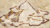
I'm not a hundred percent satisfied with the result—the tree I used for the glade isn't stylized enough to fit its surroundings, some bits of text could stand to be tweaked (a couple of them I'm not even certain that I read correctly on the original map), and if I fix those, the perfectionist in me will find something else wrong. Still, I think it's a bit of an improvement.
I played fast and loose with a lot of the original geography. Let me know if you want anything changed back/redone/tweaked/etc. If I don't hear anything in the next week or so, I'll mark it down as "finished" and stuff the layered .xcf version of the file somewhere you can grab it from.
- Attachments
-
-
francophone

- Posts: 393
- Joined: February 20th, 2010, 2:19 pm
Re: Geographical reconciliation
The chalice of victory seems too neat, too dark, compared to the rest.
Re: Geographical reconciliation
Looks great, eliddell. There's just a few things:
Bralan's Tomb
Vorgol Vale
Sored Fel is a naga city; it's supposed to be in the water.
I'm a little concerned about the mountains of Gorn; I envisioned them as a little more impassable; thus the reason that no one has ever explored this land. I'm not sure how big a deal that is, though.
The forest south of Bralan's Tomb and around Fell Marthing are a little bit sparse; both of these--in the campaigns, at least--are thick, dark, and gloomy. Again, it's not that important.
Depending on how easy it is; Brizzal's Crossing could be shifted northeast ever so slightly--the one tower looks like it's sitting in the river.
Not sure about the art for the Chalice of Victory; the neck of the Chalice looks a little bit elongated.
All in all, the map looks wonderful. I'm really pleased the the results.
Kallin Efinari
---Creator of "LOTE Unit Release", "7p - Afterwards", and "Chain Lightning"
(Working on 1.12 port of "7p - Afterwards")
Managing compatibility between 4000K people's ideas of what happens? Forget it!
---Creator of "LOTE Unit Release", "7p - Afterwards", and "Chain Lightning"
(Working on 1.12 port of "7p - Afterwards")
Managing compatibility between 4000K people's ideas of what happens? Forget it!
Re: Geographical reconciliation
Okay, take two: spelling corrections, thicker forest in the indicated areas, Sored Fel is now in the bay instead of beside it, the towers of Brizzal's Crossing are now equidistant from the water instead of skewed so that one tower is closer, and the chalice is shorter. As for the mountains, there could easily be more and higher ones off-map to the west; I was limited a bit by the amount of space on the map and the brushes I had to fill it with (if you look closely at the peaks on the map, you'll see that some of them repeat—more of them would have made the effect more noticeable, because there are a lot of mountains crammed into a relatively small space).
@francophone: The chalice is just about the only symbol on the map I drew by hand rather than using a predefined brush. It's no darker than the town symbols, but may be a bit less antialiased—at that size, it's difficult to get everything right, and I was working without proper reference (which I shouldn't have been doing, really. Mea culpa.)
@francophone: The chalice is just about the only symbol on the map I drew by hand rather than using a predefined brush. It's no darker than the town symbols, but may be a bit less antialiased—at that size, it's difficult to get everything right, and I was working without proper reference (which I shouldn't have been doing, really. Mea culpa.)
- Attachments
-
Re: Geographical reconciliation
Again, looking great. A few more changes have presented themselves to me, though:
The label for "Nerynedd's Glen" is a little too translucent; the forest interferes with the text a bit. I can't be sure, but that might be misspelled as well; the spelling at the beginning of this comment is correct.
The south-eastern plainlands are a little barren; my "design consultant" has suggested something like a monster or something; like many maps have to make the space more interesting; I'm not sure what exactly.
Sorry I didn't notice/mention these before; and thanks for the work you've been doing on this. It's looking good.
Kallin Efinari
---Creator of "LOTE Unit Release", "7p - Afterwards", and "Chain Lightning"
(Working on 1.12 port of "7p - Afterwards")
Managing compatibility between 4000K people's ideas of what happens? Forget it!
---Creator of "LOTE Unit Release", "7p - Afterwards", and "Chain Lightning"
(Working on 1.12 port of "7p - Afterwards")
Managing compatibility between 4000K people's ideas of what happens? Forget it!
Re: Geographical reconciliation
It's okay—none of that took very long to change. Take three: "Nerynedd" is now spelled correctly, the opacity on the signs layer is 10% higher, and I added a few hills and a bit more sparse forest along the river to break up the plains, since that was a quick and easy way to do it (much quicker than trying to draw in a dragon or something).
- Attachments
-
Re: Geographical reconciliation
Nice.
Took a good look at all the spellings this time; hopefully this is the last typo.
It's Grakvr Peak (I know, it's extremely difficult to pronounce. Draconians aren't known for their ease of pronunciation)
Other than that, I think the map is perfect. (I say before discovering a hundred more errors)
Took a good look at all the spellings this time; hopefully this is the last typo.
It's Grakvr Peak (I know, it's extremely difficult to pronounce. Draconians aren't known for their ease of pronunciation)
Other than that, I think the map is perfect. (I say before discovering a hundred more errors)
Kallin Efinari
---Creator of "LOTE Unit Release", "7p - Afterwards", and "Chain Lightning"
(Working on 1.12 port of "7p - Afterwards")
Managing compatibility between 4000K people's ideas of what happens? Forget it!
---Creator of "LOTE Unit Release", "7p - Afterwards", and "Chain Lightning"
(Working on 1.12 port of "7p - Afterwards")
Managing compatibility between 4000K people's ideas of what happens? Forget it!
Re: Geographical reconciliation
Looks great! Thanks so much!
Kallin Efinari
---Creator of "LOTE Unit Release", "7p - Afterwards", and "Chain Lightning"
(Working on 1.12 port of "7p - Afterwards")
Managing compatibility between 4000K people's ideas of what happens? Forget it!
---Creator of "LOTE Unit Release", "7p - Afterwards", and "Chain Lightning"
(Working on 1.12 port of "7p - Afterwards")
Managing compatibility between 4000K people's ideas of what happens? Forget it!
Re: Geographical reconciliation
No problem. Attached is the original layered image, in case you ever need it for anything (GIMP .xcf format, compressed with 7zip because that's the only way I could get it small enough).
- Attachments
-
 far_east.xcf.7z
- (2.63 MiB) Downloaded 287 times

Re: Geographical reconciliation
is there a place in the development SVN where such source maps could be kept? that way versions and variants can be tracked and released like code and incremental changes dont take a lot of space

Re: Geographical reconciliation
I found there two different Mountains of Gorn.
"Sir! We are surrounded by our enemies!" - "Excellent ! We can attack in every direction!"
"Make everything as simple as possible, but not simpler." -- Albert Einstein
No Source - No Binary - No Trust!
Map Wesnoth Springs - The great War [200x120],Player=9
"Make everything as simple as possible, but not simpler." -- Albert Einstein
No Source - No Binary - No Trust!
Map Wesnoth Springs - The great War [200x120],Player=9